PLANET SURVEY
Among the latest photos taken by the Mars Global Surveyor are pictures of the Martian North Pole and Olympic Mons.
As always, click on the small pictures to see an enlarged view. All photos have been enhanced with Adobe's ImageReady 1.0 for the smallest file size possible (this keeps you from having to wait forever for pix to download.
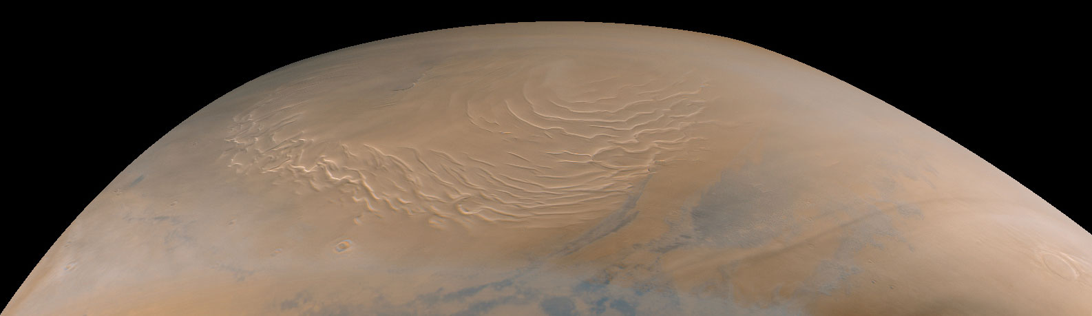
Photo taken: 9-12-98
Mars Global Surveyor's Mars Orbiter Camera obtained its last SPO-2
images of Mars on September 12, 1998. SPO-2, or "Science Phasing
Orbit-2", took place between early June and mid-September 1998.
Shown above are MOC wide angle (red and blue band) images of the
martian north polar region obtained around 3:15 a.m. PDT on September
12, 1998. The color composite ((A) above) was made using red and
blue wide angle MOC images 55001 and 55002--these were the last
pictures taken of the planet until the camera resumes its work
in late-March 1999.
The north polar layered deposits, a terrain believed composed
of ice and dust deposited over millions of years, dominates this
view. The swirled pattern in the images above are channels eroded
into this deposit. The pattern is accentuated by the illumination
and seasonal frost differences that arise on sun-facing slopes
during the summer. The permanent portion of the north polar cap
covers most of the region with a layer of ice of unknown thickness.
At the time this picture was obtained, the martian northern hemisphere
was in the midst of the early Spring season. The margin of the
seasonal carbon dioxide frost cap was at about 67° N, so the ground
throughout this image is covered by frost. The frost appears pink
rather than white; this may result from textural changes in the
frost as it sublimes or
because the frost is contaminated by a small amount of reddish
martian dust. Please note that these pictures have not been "calibrated"
and so the colors are not necessarily accurately portrayed.
In addition to the north polar cap, the pictures also show some
clouds (bluish-white wisps in (A)). Some of the clouds on the
right side of the images are long, linear features that cast similar
long, dark shadows on the ground beneath them.
When the MOC resumes imaging of Mars in March 1999, summer will
have arrived in the north polar regions and the area surrounding
the permanent polar cap will appear much darker than it does here.
The dark features surrounding the cap are sand dunes, and these
are expected to darken over the next several months as seasonal
ice sublimes and is removed from the surface.
http://mars.jpl.nasa.gov/mgs/
Photo taken 9-11-98
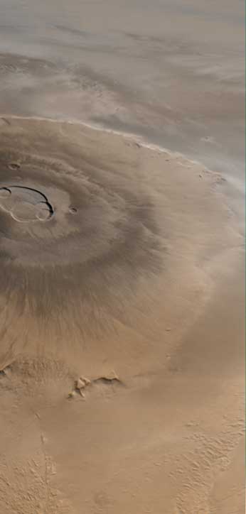
Olympus Mons is a mountain of mystery. Taller than three Mount
Everests and about as wide as the entire Hawaiian Island chain,
this giant volcano is nearly as flat as a pancake. That is, its
flanks typically only slope 2° to 5°.
The Mars Orbiter Camera (MOC) obtained this spectacular wide-angle
view of Olympus Mons on Mars Global Surveyor's 263rd orbit, around
10:40 p.m. PDT on April 25, 1998. In the view presented here,
north is to the left and east is up. The spacecraft was traveling
from north to south (left to right). Although the camera looks
straight down (towards the nadir) and cannot be pointed to the
side, the wide angle camera has such a large field of view (it
sees from
horizon to horizon) that, in effect, it provides side looking
views. Unlike some other MOC images, that have had to be warped
to provide a view as if seen from a certain direction and altitude,
this image shows what the camera saw without additional processing.
It is easy to imagine that you are looking out a window at the
surface of Mars from about 900 km (560 miles) up.
The image was taken on a cool, crisp winter morning. The west
side of the volcano (lower portion of view, above) was clear and
details on the surface appear very sharp. The skies above the
plains to the east of Olympus Mons (upper portion of view) were
cloudy. Clouds were lapping against the lower east flanks of this
26 kilometers (16 miles) high volcano, but
the summit skies were clear.
When Mars Global Surveyor attains its Mapping Orbit in March 1999,
the MOC wide angle camera system will be used to make daily, global
maps of martian clouds and weather systems. The wide angle images
will resemble weather satellite pictures of Earth, and will help
the Mars science teams plan their observations and test computer-driven
Mars weather
prediction models.
Last Updated: